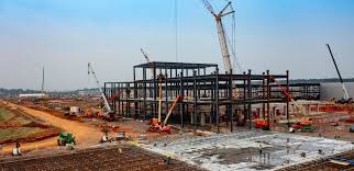
Progress Documentation
Construction Progression
RTK/PPK drone mapping, photogrammetry, and reporting — now with ground photography, LiDAR floorplan mapping, walk‑throughs, and video documentation.
Overview
Built for owners, GCs, subs, lenders, and insurers. We produce repeatable, time‑stamped visuals that reduce disputes and keep pay apps moving. No sugar‑coating: we fly what airspace allows, we QC every deliverable, and we tell you when something’s off.
Plans — Flight Cadence
Baseline Survey (one‑time)
Custom quote
RTK/PPK + optional GCPs
Safety & airspace plan
- Site mapping: orthomosaic + 3D model
- DSM/DTM & point cloud; baseline control
- Ground photography set + video overview
- LiDAR floorplan mapping (if interiors accessible)
- Baseline report for future comparisons
Monthly Progress (1 flight/mo)
Custom quote
Best for long schedules
Standard QC & reports
- Nadir + oblique capture for structures
- Ground photo & video pass each cycle
- Orthos, DSM, 3D mesh & point cloud each cycle
- Executive PDF + Web viewer link
Bi‑Weekly / Weekly Progress
Custom quote
2–4 flights per month
Critical‑path visibility
- High‑cadence capture for steel/envelope/MEP
- Ground photo & video pass; 360 walk‑through as needed
- LiDAR floorplan updates on interior milestones
- Issue callouts + timeline overlays
- Owner/GC/sub portals for alignment
Workflow
1) Pre‑Flight & Control
- RTK/PPK plan; optional GCP layout
- Airspace & safety briefing
- Scope confirmation with PM/GC
2) Capture
- Nadir + oblique patterns; low‑alt detail
- Ground DSLR photography (exterior/interior as safe)
- Stabilized video documentation pass (gimbal)
- LiDAR interior floorplan scanning (where accessible)
- Thermal spot checks (optional)
- Weather‑guarded flight windows
3) Processing & QC
- WebODM & CAD toolchain
- Checkpoints & RMS accuracy report
- Visual QA and anomaly notes
4) Delivery
- Executive PDF + single‑page summary
- Interactive viewer link for stakeholders
- GeoTIFF, DXF/DWG, LAS/LAZ, OBJ/GLTF
What You Get
Deliverables
- Orthomosaic (GeoTIFF), DSM/DTM, 3D mesh & point cloud
- Annotated image set highlighting milestones & issues
- Ground photography set + stabilized progress video (MP4)
- LiDAR floorplan mapping outputs (2D PDF/DXF; 3D on request)
- Walk‑through link (360 or video), if captured
- Measurement tables (areas, lengths, volumes)
- Accuracy summary (GCPs, checkpoints, RMS)
Add‑Ons
- Ground photography set (DSLR) — site & interior
- Video documentation — stabilized walkthrough/recap
- LiDAR floorplan mapping — 2D/3D export
- 360 walk‑through — interior path capture
- Thermal envelope scan (FLIR) — moisture/insulation
- Volumetrics — stockpiles & cut/fill
- Plan overlays — as‑built vs. design
Straight Talk
Accuracy & Limits
- Not a land survey; control improves accuracy but does not replace a licensed surveyor.
- Flights subject to FAA airspace, TFRs, local rules, and weather.
- Access, crane schedules, and site conditions can affect capture windows.
Coordination
- We coordinate with the PM/GC and site safety lead.
- Schedule holds available for weekly/bi‑weekly cadences.
- We call out issues plainly and document them.